Baikal-Amur Mainline - BAM. History of the construction of the highway, BAM on the map of Russia, dates and years of construction
The Baikal-Amur Mainline expansion project is one of the latest infrastructure initiatives of the Russian government and the management of Russian Railways, aimed at increasing transport connectivity between Russia and the countries of the Asia-Pacific region and improving conditions for industrial development in the Russian Far East.
40 years
July 8, 2014 marked forty years since the adoption of the resolution “On the construction of the Baikal-Amur Railway.” When celebrating the fortieth anniversary of BAM, during a teleconference with the President of Russia, a “silver link” was laid, which marked the beginning of the BAM-2 project.
Over these forty years, the legendary construction of communism has gone through both the stage of Komsomol enthusiasm and constant media attention, and the decline of the 1990s. In the post-Soviet period, the construction of the BAM was often mentioned as a sign of inferiority Soviet economy and an example of the inefficiency of large infrastructure projects in general.
According to the initial project, the BAM was supposed to transport up to 35 million tons of cargo per year, but by the time the USSR collapsed, the road’s capacity was only 10 million tons. As the country’s economic recovery progressed, by the mid-2000s it turned out that the highway was not only is actively used, but moreover, it is extremely overloaded.
The Baikal-Amur Mainline passes through the territory of the Irkutsk region, Transbaikal region, Amur region, Buryatia and Yakutia and Khabarovsk region.
Key stations of BAM:
- Taishet
- Taximo
- Tynda
- Neryungi
- New Urgal
- Komsomolsk-on-Amur
- Vanino
- Sovetskaya Gavan
The total length of the BAM from the city of Taishet to the port of Sovetskaya Gavan is 4,300 km.
BAM is connected to the Trans-Siberian Railway by three lines: Bamovskaya–Tynda, Izvestkovaya–Novy Urgal and Volochaevka–Komsomolsk-on-Amur.
Currently, an electrified double-track railway has been built from Taishet to Lena station (704 km). Single-track electrified road - from Lena station to Taksimo station (725 km). The remaining eastern section of the BAM is a single-track railway with diesel traction.
In 2013, 33% more cargo was transported along the BAM than in the best soviet year highways - 1988. According to the leadership of Russian railways, if the company had not worked to gradually expand bottlenecks and had not opened the Kuznetsovsky tunnel in 2012, the highway would have long ago faced large-scale congestion. According to expert assessments, by 2015, the length of sections of the Baikal-Amur Mainline with a shortage of capacity will increase by more than 3 thousand kilometers. The busiest zones will be the Novaya Chara-Taksimo and Kirenga-Lena Vostochnaya sections.
A separate incentive for the development of Siberian highways is the “Asian turn” in Russian policy that emerged in 2014, increasing the importance of trade relations with the countries of the Asia-Pacific region, and especially with China.
The main mineral deposits located near the BAM
Industrially developed deposits:
- Neryungrinskoye and Urgalskoye coal mines
- Korshunovskoye and Rudnogorskoye iron ore mines<
Well-studied fields where an economic assessment of development efficiency has been carried out:
- Apsatskoye, Ogodzhinskoye and Elginskoye coal mines
- Chineyskoye, Taignoye and Garinskoye iron ore mines
- Udokan copper
- Kuranakh and Katugin polymetallic
- Evgenevskoe Apatity
- Kovykta gas
- Talakanskoye, Verkhnechonskoye, Chayandinskoye, Srednebotuobinskoye
Fields requiring development of transport infrastructure:
- Yaraktinskoye, Dulisminskoye, Ayanskoye and Adnikanskoye oil and gas fields
Promising deposits:
- Neryundinskoye, Kapaevskoye, Polivskoye iron ore mines
- Khlodnenskoye and Shamanskoye polymetallic
- Golevskoyesynnyritov
- Ukdusk and Seligdar Apatity
- Nepa potash basin
Natural conditions
The Baikal-Amur Mainline runs through territories whose natural conditions are extremely diverse and complex. The western section of the BAM route is characterized by mountainous terrain. The eastern section of the route is characterized by the presence of mires - swamps on permafrost.
Almost all areas of the Baikal-Amur Mainline are characterized by extreme climate severity, which determines the presence of permafrost, the depth of which reaches from one to hundreds of meters.
Average annual air temperatures along the entire BAM route are negative and vary from minus 3.2 °C (Nizhneangarsk indicator) to minus 7.8 °C (Chary indicator). The absolute minimum air temperature on the highway was minus 60 °C, the absolute maximum was plus 40 °C.
The route of the highway runs through zones of high seismicity (up to 9 points on the Richter scale).
The BAM crosses eleven deep rivers, including the Lena, Amur, Zeya, Vitim, Olekma, Selemdzha and Bureya. In total, the BAM crosses more than 3,500 watercourses. The highway passes through 7 large mountain ranges, including Baikalsky, Severo-Muysky, Udokansky, Kodarsky, Olekminsky Stanovik, Turansky and Dusse-Alinsky.
Numerous active physical and geological processes are observed along the entire length of the highway. In the mountainous areas of the highway, mainly from Kirenga to Tynda and from Urgal to Berezovka, mudflows are a frequent natural disaster. The sections of the highway passing through the Baikal and North-Muysky ridges are most at risk of snow avalanches. In total, 294 avalanche complexes were identified in the BAM area.
Despite taking into account the avalanche risk when laying the BAM route, avalanches periodically occur along the way
So, in 2011, due to an avalanche, a train traveling from Severobaikalsk to Kirenga derailed. To protect against the risks of landslides and rockfalls, which are quite high on all mountain sections of the route, the construction of galleries was often used during the construction of the BAM. Geological risks of the highway significantly complicate both new construction and ongoing operation.
BAM-2 project
According to expert estimates, the volume of export of minerals from the fields of eastern Russia will double by 2020 and reach 113.2 million tons per year.
Increasing the production of raw materials, the construction of new industrial enterprises along the BAM route, as well as increasing the capacity of the ports of Vanino and Sovetskaya Gavan Gavan - the main gateway for Russian exports to the Asia-Pacific countries - will lead to the emergence of bottlenecks along almost the entire length of the BAM. The greatest capacity deficit is expected on the Vysokogornaya–Vanino section.
The project to expand the Baikal-Amur Mainline provides for the construction of a second branch of the main line along most of the route, electrification of certain sections and replacement of rolling stock. The demand for transportation along the BAM by 2025 will be about 100 million tons of cargo.
According to the head of the Irkutsk group of the Directorate for Reconstruction and Construction of Railway Transport Facilities of JSC Russian Railways, Evgeniy Solntsev: “... the volume of upcoming design and construction work is huge and comparable to the volume of construction of the BAM in Soviet times, and the construction time is much shorter. By 2017, it is necessary to double the capacity of BAM - from 16 to 32 pairs of trains per day, for which it is necessary to reconstruct more than 500 kilometers of second tracks, 90 stations, 85 bridges and build a new Baikal tunnel.”
According to a statement made by the head of Russian Railways, Vladimir Yakunin, in his blog, after the completion of the reconstruction of the BAM, most of the cargo will be redirected to the mainline - the transit of coal and minerals will at least double, which will allow Russia to further increase international trade turnover, in particular with China.

Project financing
Expert estimates of the total amount of required financing vary, but the approximate amount of investment required for the development of the BAM along its entire length for the period until 2020 is about 400 billion rubles.
According to the passport of the investment project “Modernization of the railway infrastructure of the Baikal-Amur and Trans-Siberian railways with the development of throughput and carrying capacity,” which is currently awaiting approval by the Government of the Russian Federation, total investments in the project are provided in the amount of 562.4 billion rubles, of which 300 billion rubles. it will be necessary to provide JSC Russian Railways with 150 billion rubles. – funds from the National Welfare Fund (NWF), 110 billion rubles – subsidies from the budget. In 2014, it is planned to carry out work worth 61.4 billion rubles; the total volume of contracts concluded in 2014 is estimated by Russian Railways at 90 billion rubles. 50 billion rubles will be attracted from the National Welfare Fund, the rest will be monopoly money.
The excavation of the second Baikal tunnel by mountain method is expected to begin this year.
Currently, near the western portal of the existing tunnel, located on the border of the Irkutsk region and the Republic of Buryatia, a rotation camp for 300 workers is being built from scratch.
“The new tunnel, which is planned to be commissioned in 2017, will significantly increase the capacity of this “bottleneck” of the Baikal-Amur Mainline, and the speeds will increase,” Viktor Khlyupin, head of the Severobaikalsk tunnel distance of the East Siberian Infrastructure Directorate, noted in an interview with the Gudok newspaper. .
Preparations are now underway to begin construction of the second corridor inside the Baikal ridge. The new corridor of the Baikal tunnel will be laid parallel to the existing one. In 2014, more than 2.1 billion rubles will be allocated for the construction of the tunnel.
Prospects and engineering protection
The scale of the Baikal-Amur Mainline expansion project is comparable to the volume of highway construction in Soviet times. At the same time, builders will be forced to work under much tighter deadlines. To ensure growth in exports from new fields and industrial enterprises, by 2017 it is necessary to double the throughput capacity of the highway.
The complexity of the terrain on the BAM route, high seismicity and avalanche risks make it necessary to introduce new and unique solutions in the field of engineering protection of transport routes
In this direction, as well as in general issues of project development, the experience gained during the implementation of the Sochi project will provide great assistance to builders. Russian construction organizations have gained experience in construction in a short time, in difficult mountain conditions and with high landslide, mudflow and avalanche risks. At one time, the Sochi Olympics was nicknamed the “Second BAM”. Now Russia has the opportunity to implement a real BAM-2 and balance its transport structures between the West and the East.
The construction of the Baikal-Amur Mainline required the mobilization of enormous resources from the entire country. Even before the highway was completed, many declared the construction pointless and unnecessary. There is still a lot of controversy surrounding the history of the construction of BAM. What exactly is the Baikal-Amur Mainline? Is this the way to the future or a huge mistake of the Soviet regime? Below are some pretty interesting facts, read and draw your own conclusions.
In 1888, the Russian Technical Society discussed the project of building a Pacific railway through the northern tip of Lake Baikal, after which in July - September 1889, Colonel of the General Staff N.A. Voloshinov with a small detachment covered a thousand-kilometer space from Ust-Kut to Mui - just along to the places where the BAM route now lies. And he came to the conclusion: “...drawing a line in this direction turns out to be absolutely impossible due to some technical difficulties, not to mention other considerations.” Voloshinov was not a pessimist, but he soberly realized: Russia at that time had neither the equipment nor the means to carry out grandiose work.

In 1926, the Separate Corps of Railway Troops began to conduct topographical reconnaissance of the future BAM route. In 1932, the Council of People's Commissars of the USSR issued a decree “On the construction of the Baikal-Amur Railway,” according to which design and survey work was launched and construction began. By autumn it became clear that the main problem in construction was the shortage of workers. With an officially established number of workers of 25 thousand people, it was possible to attract only 2.5 thousand people. As a result, on October 25, the second resolution of the Council of People's Commissars of the USSR was issued, according to which the construction of the BAM was transferred to the special management of the OGPU.

Following this, the construction of three connecting lines from the Trans-Siberian Railway to the planned BAM route continued (mainly by prisoners of the Baikal-Amur ITL (Bamlag)): Bam - Tynda, Volochaevka - Komsomolsk-on-Amur, Izvestkovaya - Urgal. In 1937, the general direction of the BAM route was determined: Taishet - Bratsk - the northern tip of Lake Baikal - Tyndinsky - Ust-Niman - Komsomolsk-on-Amur - Sovetskaya Gavan. In 1938, construction began on the western section from Taishet to Bratsk, and in 1939, preparatory work began on the eastern section from Komsomolsk-on-Amur to Sovetskaya Gavan. In January 1942, by decision of the State Defense Committee, track links and bridge trusses were removed from the Bam-Tynda section built by that time for the construction of the Stalingrad-Saratov-Syzran-Ulyanovsk railway line (Volzhskaya Rokada).

The photo shows a map of the Baikal-Amur Mainline
In June 1947, construction of the eastern section of Komsomolsk-on-Amur - Urgal continued (mainly by prisoners from the Amur ITL (Amurlag)). Before Amurlag was disbanded (in April 1953), embankments were poured throughout the entire section, tracks were laid, and bridges were built on the section Komsomolsk-2 - Berezovy (Postyshevo). The Komsomolsk-on-Amur - Sovetskaya Gavan section was put into operation in 1945, and train traffic on the Taishet - Bratsk - Ust-Kut (Lena) line opened in 1950. Below is a map where the Baikal-Amur Railway is marked in green, with the Trans-Siberian Railway in the background.


It is more than likely that the BAM would have been built much earlier than the famous Komsomol construction began in 1974. After all, from 1947 to 1958 alone, prisoners completed 24 million m3 of earthworks, laid 840 km of main and station tracks, built 55 stations and sidings, 5 locomotive depots, 9 power plants, 19 water supply points, 90 thousand square meters of living space near the BAM.
However, as you know, after Stalin’s death, many “cult” projects had to be frozen

One way or another, the official “birthday” of BAM is considered to be July 8, 1974, when the resolution of the Central Committee of the CPSU and the Council of Ministers of the USSR No. 561 “On the construction of the Baikal-Amur Railway” was issued.

The smiles on the faces of the young people who left Moscow on April 27, 1974 for the construction of the Baikal-Amur Mainline were the most sincere. Not all of them “lasted” on BAM for long enough; literally only a few returned to Moscow on the no less legendary train, which arrived at the Yaroslavl station on the Tynda-Moscow flight in January 1984.

It was from this moment that the active construction of the highway began in many directions at once by the forces of Komsomol construction “landing forces” and units of the Railway Troops. Here one cannot fail to note the traditional nature of the solution: to use soldiers instead of prisoners in construction.


In 1977, the Bam - Tynda line was put into permanent operation, and in 1979, the Tynda - Berkakit line. The main part of the road was built over 12 years - from April 5, 1972 to October 27, 1984, and on November 1, 1989, the entire new three-thousand-kilometer section of the highway was put into permanent operation within the scope of the launch complex. The longest tunnel in Russia (15,343 meters), the construction of which began in May 1977, was completed only in March 2001 and put into permanent operation in December 2003.

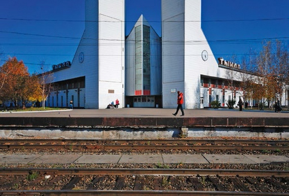
The photo shows a large junction railway station in Tynda
Such a large-scale construction project was only possible for a great power, with its colossal economic power and resources. 60 sectors of the national economy, hundreds of supplier enterprises, design and scientific organizations took part in providing the construction with everything necessary. BAM is rightly called the route of friendship and brotherhood. It was built by representatives of 70 nationalities of the USSR.


A General Scheme for the regional planning of the BAM zone of influence was developed, taking into account the regional characteristics of the route, specific factors of economic development of the adjacent territories, as well as the multinational features of architectural and planning solutions, the construction art of all the republics participating in the development of the highway. Tynda, Neryungri, Severobaikalsk - the largest cities along the route - were built precisely according to the master plans. As a result, each had its own appearance, its own special architectural “accents”. However, like any new business, the Baikal-Amur Mainline aroused interest in environmental problems. Virgin nature demanded careful treatment. After all, a delicate natural organism, balanced over millennia, is especially fragile in conditions of permafrost, high seismicity and low temperatures.

It was important to use the powerful technology in the builders’ arsenal wisely, carefully and skillfully, so that the industrial power of the BAM would be organically combined with the natural landscape, clean air, and the transparency of rivers and lakes. The extreme conditions of the route required new scientific, technical, engineering and production solutions.

Here, for the first time in world practice, a fundamentally new design of bridge support foundations was created, a number of new ideas were implemented in tunnel construction, technologies for backfilling the roadbed and drilling and blasting operations in permafrost conditions were developed, and modern methods of combating ice deposits appeared. The highway passed through the region in northern areas rich in natural resources.

Where previously only a nomadic Evenk hunter could reach on his reindeer, where geologists only occasionally flew in by helicopter, the taiga was awakened by the whistle of a diesel locomotive, and residential settlements sprang up. Previously, the southern regions of the Amur region were connected to the North by the AYAM (Amur-Yakutsk Mainline) highway, running from Bolshoi Never on the Trans-Siberian Railway to Chulman. And now this thin transport stream was replaced by a “full-flowing river” called BAM. But it must be admitted that BAM turned out to be unprofitable. The number of trains and freight traffic did not correspond to the original plans.

The main mistake was the emphasis on the actual construction of the route to the detriment of the development of production infrastructure. The “hammering of crutches” became an end in itself and was not sufficiently supported by the use of mineral deposits made available as a result of the construction of the railway.

The Baikal-Amur Mainline is one of the largest railway lines in the world. The construction of the main part of the railway, which took place in difficult geological and climatic conditions, took more than 12 years, and one of the most difficult sections - the North Muisky tunnel - was put into permanent operation only in 2003.

The Severomuysky ridge was one of the most difficult sections of the BAM. Before the opening of the Severomuysky tunnel, trains followed a bypass railway line laid through the ridge.

In 1985 - 1989, a new bypass line, 54 km long, was built, consisting of numerous steep serpentines, high viaducts and two loop tunnels (the old bypass was subsequently dismantled). The “Devil's Bridge” became famous - a viaduct in a sharp turn on a slope across the valley of the Itykyt River, standing on two-tier supports. The train was forced to maneuver between the hills, moving at a maximum speed of 20 km/h and risking being caught in an avalanche. On ascents there was a need to push the trains with auxiliary locomotives. The section required large expenses for maintaining the track and ensuring traffic safety. In the photo is the Devil's Bridge:

The construction of the tunnel through the ridge took more than 25 years. The first train passed through the tunnel on December 21, 2001, but the tunnel was accepted into permanent operation only on December 5, 2003. The total length of the tunnel's mine workings is 45 km; Along the entire length of the tunnel there is a working of a smaller diameter, used for pumping water, placing engineering systems and delivering technical personnel. Ventilation is provided by three vertical shafts. The safety of trains passing through the tunnel is ensured, among other things, by seismic and radiation monitoring systems. To maintain the microclimate in the tunnel, special gates are installed on both of its portals, which are opened only for the passage of trains. The tunnel's engineering systems are controlled by a special automated system developed at the Design and Technology Institute of Computer Science of the Siberian Branch of the Russian Academy of Sciences.

Along with the tunnel, the Severomuysky bypass is also maintained in working order - it is expected that it can be used in the event of an increase in freight traffic along the BAM. Many trains now travel along the Baikal-Amur Mainline.
In 2007, the government approved a plan according to which it was planned to build “capillary” branches to mineral deposits. It was also previously decided to build a crossing in the form of the Sakhalin tunnel or bridge:

In 2009, reconstruction of the Komsomolsk-on-Amur - Sovetskaya Gavan (Far Eastern Railway) section began with the construction of a new Kuznetsovsky tunnel, it is planned to be completed in 2016.

Now 8 trains pass along the BAM every day, the volume of transportation is 8 million tons of cargo per year. In general, BAM, even today, is a treasure trove of railway records: the harshest climatic conditions, the longest tunnels, the highest bridges, the most original engineering solutions.

According to Strategy 2030, the volume of investments in BAM will be about 400 billion rubles. 13 new railway lines with a total length of about 7 thousand kilometers will be built. All these plans for the future and strategies still do not allow us to call the BAM a road without a future, and it is no coincidence that work on the construction of the North-Muysky tunnel was not curtailed even in the most difficult times for the Russian economy. Despite everything, the history of the Baikal-Amur Mainline continues...
Photo album about construction and life at the shock Soviet construction site:


Diver at bridge construction


Girls of the Bamovsky village. 1977


The first train at the zero kilometer of BAM. Lena Station 1975


Port Vostochny


Tynda. Caption for the photo with a fireplace: “... cozy houses have been built for the workers of the BAM in Tynda. Living room in the house of the master of the path...".


The Baikal-Amur Mainline (BAM) runs through the territory of the Irkutsk Region, Trans-Baikal Territory, Amur Region, the Republics of Buryatia and Sakha (Yakutia), Khabarovsk Territory.
Key stations of BAM:
- Taishet;
- Lena;
- Taximo;
- Tynda;
- Neryunga;
- New Urgal;
- Komsomolsk-on-Amur;
- Vanino;
- Sovetskaya Gavan.
Total length of BAM from Taishet to Sovetskaya Gavan is 4300 km.
BAM is connected to three connecting lines: Bamovskaya - Tynda, Izvestkovaya - Novy Urgal and Volochaevka - Komsomolsk-on-Amur.
Currently, a double-track railway has been built from Taishet to Lena (704 km) and a single-track railway from Lena to Taksimo (725 km). On the remaining section of the BAM, a single-track railway with diesel traction was built.
The BAM passes through an area with harsh natural and climatic conditions - through areas of permafrost (the depth of which is from 1-3 to hundreds of meters) and high seismicity (up to 9 points). The highway crosses 11 full-flowing rivers (among them the Lena, Amur, Zeya, Vitim, Olekma, Selemdzha, Bureya) and 7 mountain ranges (Baikalsky, Severo-Muysky, Udokansky, Kodarsky, Olekminsky Stanovik, Turansky and Dusse-Alinsky). Due to the difficult terrain, more than 30 km of the railway passes through tunnels (among them Baikalsky (6.7 km) and Severo-Muysky (15.3 km)).
During the construction of BAM, the latest designs were used, new methods for constructing and operating facilities in difficult hydrogeological conditions were developed and patented.
History of the construction of BAM
The prerequisites for the start of construction of the Baikal-Amur Mainline were the disappointing results of the Russian-Japanese War of 1904-1905, which showed the urgent need for the construction of a second railway in the east of the country, duplicating the Trans-Siberian Railway.
According to the original plan, the highway was supposed to run from Ufa along the shortest distance to the eastern sea coast through the northern tip of Lake Baikal.
During Soviet times, research to develop a railway network in the east of the country resumed in the late 1920s. - early 30s It was then that the road from Taishet to the east first received its modern name - the Baikal-Amur Mainline. It was proposed to start the road from Urusha station (approximately the middle of the current BAM in the Skovorodina area), and the final destination was planned to be Komsomolsk-on-Amur, which was then the village of Perm.
In 1932, the Council of People's Commissars adopted a resolution "On the construction of the Baikal-Amur Mainline", which approved the construction plan for BAM. Construction was planned to be completed in 3 years: through traffic along the entire highway in operational mode was to be opened by the end of 1935.
However, the construction of the highway was repeatedly stopped for various reasons (lack of labor, the Great Patriotic War, earthquakes in the construction area in the late 1950s).
Active construction of the BAM was resumed in 1974. The main drivers of the construction were Komsomol volunteers and military builders. Republican Komsomol detachments competed with each other and had “their own” objects: the largest Urgal station was built by the Ukrainian SSR, Muyakan station - Belarus, Uoyan - Lithuania, Kichera - Estonia, Tayura - Armenia, Ulkan - Azerbaijan, Soloni - Tajikistan, Alonku - Moldova. Tynda, the capital of BAM, was built by Muscovites.
By 1980, the Baikal-Amur Railway was organized with the location of the road management in Tynda.
On September 29, 1984, the “golden” connection took place at the Balbukhta junction(Kalarsky district, Chita region). The eastern and western directions of the BAM builders met, moving towards each other for 10 years. On October 1, the laying of the “golden” links of the BAM took place at Kuanda station (Kalarsky district, Chita region).
The final completion of the construction of the Baikal-Amur Mainline can be considered December 5, 2003 when was Traffic through the North Muisky Tunnel is open. In terms of its length (15,343 m), it is the longest tunnel in Russia and the fifth in the world. According to the construction conditions, the tunnel has no analogues: permafrost, abundance of groundwater, landslides, landslides, tectonic faults.
BAM now
The construction of the BAM solved problems at the national level:
- access to the natural resources of a huge region is open;
- transit transportation is provided;
- the shortest intercontinental East-West railway route was created, running for 10,000 km along Russian railways;
- in a military-strategic sense, the highway counters possible disruptions and interruptions in train traffic on the Trans-Siberian Railway.
Currently, the socio-economic potential of BAM has not been fully realized. The operation of this highway does not bring profit to JSC Russian Railways. The main reason for the current situation is the slow development of adjacent territories. Of the planned nine territorial production complexes that were supposed to ensure the loading of the BAM, only one was implemented - in the Neryungri coal basin.
In the direction Taishet - Tynda - Komsomolsk-on-Amur the volume of freight traffic is about 12 million tons per year. The limitation of the capacity of sections of the BAM is caused by the closure of separate points during the decline in traffic in the 90s, the presence of sections where the time between repairs was violated, there are defects in the roadbed, the upper structure of the track and artificial structures.
BAM carries about 12 million passengers a year. The intensity of passenger train traffic along the mainline is insignificant - 1-2 pairs of trains per day on the Komsomolsk-Severobaykalsk section and 9-16 pairs on the western section.
Prospects for the development of BAM
The strategic position of the BAM, the technical and economic potential of the area where it passes is so enormous that it will certainly be in demand by Russia in the foreseeable future.
The main mineral deposits of the BAM gravity zone
Deposits that are currently being developed on an industrial scale and play a cargo-forming role in loading the Baikal-Amur Mainline:
- Neryungrinskoye and Urgalskoye coal mines;
- Korshunovskoye and Rudnogorskoye iron ore mines.
The most studied deposits with estimated economic efficiency of development:
- Apsatskoye, Ogodzhinskoye and Elginskoye coal mines;
- Chineyskoye, Taignoye and Garinskoye iron ore mines;
- Udokan copper;
- Kuranakh and Katuginskoye polymetallic;
- Evgenievskoye Apatity;
- Kovykta gas;
- Talakanskoye, Verkhnechonskoye, Chayandinskoye, Srednebotuobinskoye, Yaraktinskoye, Dulisminskoye, Ayanskoye and Adnikanskoye oil and gas fields.
The development of these deposits requires the development of transport infrastructure.
Promising fields requiring additional exploration and assessment of the economic efficiency of development:
- Neryundinskoye, Kapaevskoye, Polivskoye iron ore mines;
- Khlodnenskoye and Shamanskoye polymetallic;
- Golevskoe synnyritov;
- Ukdusk and Seligdar Apatity;
- Nepa potash basin.
The Baikal-Amur Mainline is one of the largest railways in the world. Its construction played a strategic role in the development of the Siberian region, became a catalyst for the formation of manufacturing enterprises, the emergence of new cities, and provided jobs for thousands of residents of the country.
Design
The Russian government decided on the need to build the Baikal-Amur Mainline at the end of the 19th century. A road running through the north of Lake Baikal would be a breakthrough in the development of the eastern territories. After the end of the war with the Japanese, it was necessary to solve the problems of supplying the hard-to-reach eastern regions. The First World War, revolutions and their consequences forced us to postpone this issue - in the USSR at that time there was neither technology nor the ability to implement a large-scale project.
They took it up again only in 1930. At a government meeting, special organizations were instructed to begin work on a railway project that would duplicate the Trans-Siberian Railway, but would be located to the north and provide access to the Pacific coast. At the same time, the new routes were given a name - the Baikal-Amur Mainline. Large ones approach the Irkutsk and Amur regions, run through the Republic of Buryatia and the inaccessible lands of Yakutia. Already in 1933, the first area of the railway track was installed.
Construction
Full-scale work on the construction of the BAM, connecting Taishet and Sovetskaya Gavan, a city near the ocean, started in 1937. BAM immediately received an unofficial name - “construction of the century.” And this is not surprising. The construction of the Baikal-Amur Mainline dragged on for many years, was stopped for several years due to the war, then due to lack of funding. To this day, BAM is one of the most expensive projects implemented in the 20th century.

Thousands of prisoners were recruited from all prisons and camps in the country for construction. The authorities agitated the population to take part in the construction of the road, which was supposed to become the future of the state. The builders were provided with housing and all the necessary conditions. With the construction of the road, the
Between 1942 and 1947, work was suspended due to the war. The next stop occurred in 1953. The expensive project required large capital investments and human resources.
Construction resumed only after almost 20 years - in 1974. The “construction of the century” began again at an accelerated pace; several directions were developed and mastered at once. It took another 12 years to connect all the sections. During this time, a total of about 2 million construction workers worked at different sites in several regions of the country. In 1989, BAM fully appeared on the map of Russia. Then it was officially put into operation.
Baikal-Amur Mainline: major transport hubs
BAM begins at the Taishet station of the Trans-Siberian Railway and then goes to the East. This is where the starting point of the road is located, connecting the two most ambitious transport projects in the country. When the Baikal-Amur Mainline was built, large transport hubs began to actively “overgrow” with population due to construction workers from all over the country who came here to work and then stayed for permanent residence.

The key stations of the road were: Taishet, Tynda, Neryungri, Komsomolsk-on-Amur, Sovetskaya Gavan. BAM was the first railway on the territory of Yakutia, which, due to severe natural conditions, remained cut off from the country for a long time, and communication was carried out exclusively through air travel.
Development of territories around BAM
The designers, connecting the Trans-Siberian Railway with the Pacific coast, chose a path for the future road that would cover the largest mineral deposits. In this way it was planned to increase the efficiency of transportation. The railways were supposed to bring tangible profits and facilitate the process of transporting minerals.

The most studied coal deposits along the BAM route are the following: Ogodzhinskoye and Elginskoye, copper Udokanskoye, oil and gas deposits in Talakansky, Verkhnechonsky, Yaraktinsky and other areas. There are also significant deposits of iron ores, copper, polymetals, apatites and gas in other sections of the route. To increase the performance and efficiency of work at these facilities, it is necessary to establish and ensure delivery of minerals in the region directly to the place of loading into the car.
The largest stations along the road
Thanks to the construction of the road, the cities of Ust-Kut and Tynda received the status (the latter began to be called the “heart of BAM”). Taishet is a strategically important station, the point where the Baikal-Amur Mainline begins. Large transport hubs also pass through Tynda, from which there are 2 branches: to the North (to Neryungri) and to the South (to Skovorodino), thus connecting with the Trans-Siberian Railway.

The final station is the city of Sovetskaya Gavan, located on the shores of It is known for another long-term construction project - an underwater tunnel that was supposed to connect Sakhalin and the mainland. This project has not yet been implemented. There are 3 stations in Sovetskaya Gavan, but passenger trains stop in another, neighboring area. Also, in order to travel to the West of the country by passenger train, you must go through Vladivostok, which can be reached with trailer cars.
Other railways in the region
The Baikal-Amur Mainline is subordinated to the Eastern Railway on the Siberian section, and to the Far Eastern Railway on the territory of the Amur Region and Khabarovsk Territory. The BAM repeats the Trans-Siberian Railway, which runs along the southern border of Russia (similarly through the Siberian and Far Eastern territories).
BAM development plans
The main problem with this remains that, despite more than 15 years of operation, it is still unprofitable. The railway tracks have enormous potential, which this road contained when the designers created it, but it has not yet been realized.

The main difficulties are that there are no communication routes to the main deposits of minerals and ores. After completion of construction, it was decided to continue to develop the direction, but first due to the collapse of the USSR, then due to the unstable economic situation in the 90s and the global economic crisis in the early 2000s, plans were repeatedly postponed. In 2011, Vladimir Putin raised this topic again. It is planned to increase train speed, throughput and carrying capacity.
General characteristics of the Baikal-Amur Mainline
The total length of the road is 4,300 kilometers, mainly consisting of one track. The two-track railway was built only from Taishet to Lena and has a length of about 700 kilometers.
The construction of the BAM was complicated by difficult natural conditions. In many areas it was necessary to build on permafrost lands, in earthquake-prone areas. 11 bridges were built across deep rivers, and more than 30 kilometers of road runs through tunnels in rocks. The mountainous terrain also significantly complicated the construction of the railway.
April 27, 2009 marked 35 years since the day when the first All-Union Komsomol shock detachment, a detachment named after the XVII Congress of the Komsomol, set off to build the Baikal-Amur Mainline. This day became the day of the second birth of BAM - with it the active construction of the highway began in several directions at once.
The Baikal-Amur Mainline (BAM) is a railway in Eastern Siberia and the Far East, the second main (along with the Trans-Siberian Railway) railway access of Russia to the Pacific Ocean.
The Baikal-Amur Mainline runs from Taishet to Sovetskaya Gavan and runs through the territory of the Irkutsk, Chita, Amur regions, Buryatia and Yakutia, and the Khabarovsk Territory. The total length of the highway is 4,300 kilometers.
The main line of the BAM - section Ust-Kut (on the Lena River) - Komsomolsk-on-Amur (3110 km); it is adjacent to two sections built in the late 1940s - early 1950s (Taishet - Ust-Kut and Komsomolsk-on-Amur - Sovetskaya Gavan).
The BAM is connected to the Trans-Siberian Railway by three connecting lines: Bamovskaya - Tynda, Izvestkovaya - Urgal and Volochaevka - Komsomolsk.
By 2015, it is planned to build 8 sidings, 2 low-power slides and 18 additional tracks at BAM; reconstruction of the Korshunovsky tunnel is also planned.
The material was prepared based on information from RIA Novosti and open sources